By: Nur Atirah Muhadi, Ahmad Fikri Abdullah, Siti Khairunniza Bejo, Muhammad Razif Mahadi and Ana Mijic
Article Prepared By: Farah Izana Abdullah
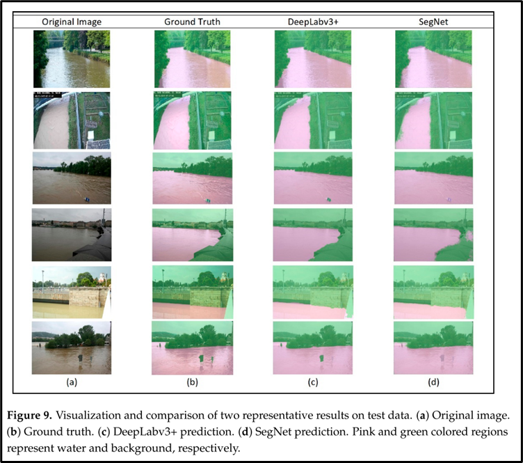
There were 367 disaster events on average per year worldwide, with floods accounting for 44% of total events. Malaysia also experienced an increase in rainfall extreme in December 2014, which led to the worst flooding in decades, affecting more than 200,000 residents and more than RM2.5 billion economic losses. Thus, the flood issue has gained attention globally with significant efforts being made to develop effective flood prevention and monitoring solutions. Currently, the primary approaches to monitoring flood events are sensor measurements and remote sensing. However, the main restriction of using these sensors is the limited number of sensor installations due to the high cost of installation and maintenance. Besides, the water level sensor provides only point-based information and the data cannot be visualized, thus it does not accurately represent the actual condition at sites. For remote sensing approach, it is not easy to extract information within a specific small area from satellite imagery. Therefore, the surveillance camera has become a popular alternative to be used as an input source for flood monitoring events, especially in a small-scale areas. In this study convolutional neural networks (CNN) was proposed to identify water regions from the surveillance images. River water levels were predicted based on the elevation from the predefined markers using two well-established deep learning algorithms, DeepLabv3+ and SegNet networks. Both networks successfully distinguished water regions from the background but the outputs from DeepLabv3+ were more accurate than the results from the SegNet network. It can be concluded that the proposed approach has high potential as an alternative monitoring system that offers water region information and water level estimation for flood management and related activities.
Web: https://doi.org/10.3390/ app11209691
Date of Input: 01/04/2022 | Updated: 01/04/2022 | m_fakhrulddin
MEDIA SHARING